
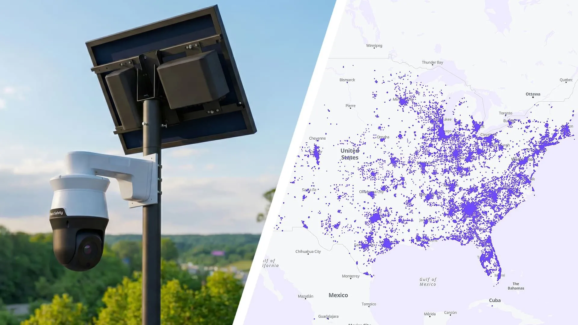
How did the Flock cameras map come to exist?
The Flock cameras map is the result of security research conducted by Joshua Michael, who identified vulnerabilities in how Flock Safety managed its server data. Michael discovered that the company was inadvertently leaking the specific locations of its automated license plate reader (ALPR) devices through its own servers. This data leak provided a blueprint of the company's vast surveillance infrastructure, which Proton has now integrated into a user-friendly interface.
The research has not been without conflict. Flock has reportedly attempted to force the removal of Michael's research website. However, both the original research site and the Proton-hosted map remain accessible to the public. This tension highlights the ongoing struggle between private surveillance corporations and privacy advocates who seek to make the extent of public monitoring visible to the citizenry.
The role of data leaks in privacy research
In the realm of cybersecurity, data leaks often serve as the primary catalyst for public awareness. In this instance, the inadvertent exposure of server data allowed a researcher to compile a comprehensive inventory of hardware that is otherwise obscured from public view. While corporations often view such disclosures as security failures or intellectual property risks, privacy advocates argue they are essential for democratic oversight.
What does the Proton Flock map reveal about surveillance density?
The Proton map provides a granular view of the global ALPR footprint, showing a heavy concentration of technology in North America. When viewed at a global scale, the map displays 214,073 active devices. The vast majority of this network is localized to the United States and Canada, which account for 213,712 of the total count. This concentration suggests that North American municipalities are the primary adopters of Flock's automated tracking technology.
Users can interact with the map to find specific information about the surveillance environment in their immediate vicinity. The platform allows for several levels of filtering and searching to help users understand the specific capabilities of the cameras near them. This includes:
- Geographic Filtering: Users can search by zip code or filter results by specific US states.
- Operational Status: The map distinguishes between devices that are currently in service, those that are planned, those that have been decommissioned, and those with an unknown status.
- Technical Capabilities: Filters allow users to identify whether a device is capable of reading license plates or if it supports freeform search terms to track specific individuals.
For every camera identified, the map provides exact longitudinal and latitudinal coordinates, alongside the date the device was added to the dataset. This level of detail transforms abstract surveillance concerns into concrete, localized data points.
Why is the accuracy of the map a point of debate?
While the Proton map is highly detailed, it is important to understand that it is not a real-time live feed of every new installation. The dataset is based on a snapshot of information compiled by Joshua Michael in December 2025. Because this specific snapshot was used as part of a formal research paper, Michael has stated that his map will not be updated to add new devices or remove decommissioned ones.
This means there is a temporal gap in the data. Any Flock devices installed after December 2025, or any units that have been taken offline since that date, will not be reflected in the current Proton map. Consequently, while the map is an excellent tool for understanding the scale of the network, it should be viewed as a high-fidelity historical record rather than a real-time tracking tool.
How does Proton's map compare to DeFlock?
There is another significant project in this space known as the DeFlock campaign, which offers a different approach to mapping ALPR technology. While the Proton map relies on the specific December 2025 snapshot from Michael's research, DeFlock utilizes crowdsourced data. This difference in methodology leads to variations in both the scope and the density of the information provided.
The comparison between the two tools reveals a trade-off between depth of specific manufacturer data and breadth of general surveillance data. The following table summarizes the primary differences between the two mapping efforts:
Although DeFlock includes a wider variety of camera manufacturers and offers more comprehensive data for the Canadian market, it currently shows significantly fewer total devices in the United States compared to the Proton map. When used together, these two resources provide a more holistic view of the automated license plate reader landscape.
What is the motivation behind publishing this data?
Proton has explicitly justified its decision to host and publish this map as a matter of public right-to-know. The privacy firm argues that citizens deserve to understand the extent of the recording technology used when they leave their homes. This is particularly critical given that the data is controlled by a private entity, and the exact methods by which law enforcement agencies utilize this information remain opaque.
By making this information accessible, Proton aims to empower individuals to make informed decisions about their movements and privacy. The firm suggests that the map can serve as a tool for civic engagement, encouraging users to contact municipal leaders regarding the deployment of surveillance technology in their local communities. The underlying concern is that without such transparency, the expansion of ALPR networks could occur without sufficient public oversight or debate.
Frequently asked questions
What kind of data does the Proton Flock map provide?
The map provides precise longitudinal and latitudinal coordinates for over 214,000 Flock cameras. It also includes the date the device was added to the dataset and allows users to filter by device status, such as active, planned, or decommissioned, as well as specific technical capabilities.
Is the information on the map real-time?
No, the map is based on a data snapshot from December 2025. Because the data was used for a formal research paper, the specific dataset used by Joshua Michael and Proton is static. Therefore, any cameras installed or removed after December 2025 will not appear on the map.
How does DeFlock differ from the Proton map?
DeFlock uses crowdsourced data and covers multiple camera manufacturers like Genetec and Motorola, whereas the Proton map focuses specifically on Flock devices. DeFlock also provides more detailed information for Canada, although it currently shows fewer total devices in the United States than the Proton map.
Can I find cameras near my house using the map?
Yes, the Proton map allows you to enter your zip code to locate nearby Flock devices. You can also filter the results to see if the cameras in your area are currently in service or if they have the capability to read license plates.
Why did Proton decide to release this map?
Proton released the map to ensure transparency regarding private surveillance. They argue that people have a right to know when they are being recorded by private companies and that this information helps citizens make informed decisions about their privacy and engage with local government.
Key takeaways
- Proton's map identifies over 214,000 Flock cameras, with the vast majority in the US and Canada.
- The dataset is based on a December 2025 snapshot and does not include real-time updates.
- The map provides exact GPS coordinates and operational status for each identified device.
- DeFlock offers a broader manufacturer scope through crowdsourcing, while Proton offers higher density for Flock.
The future of ALPR transparency
The emergence of the Proton Flock map and the DeFlock campaign marks a significant shift in the landscape of digital privacy. For years, the deployment of automated license plate readers has occurred largely out of the public eye, managed by private contracts and law enforcement agencies. By turning leaked and crowdsourced data into actionable maps, privacy advocates are forcing a conversation about the scale of modern surveillance. As these tools become more widely used, they will likely play a crucial role in how citizens monitor, challenge, and ultimately regulate the growth of the automated surveillance state.
| Feature | Proton/Michael Map | DeFlock Campaign |
|---|---|---|
| Primary Data Source | Security research snapshot (Dec 2025) | Crowdsourced data |
| Manufacturer Scope | Exclusively Flock devices | Flock, Genetec, Motorola, and others |
| US Device Count | 213,712 (approx.) | 144,457 |
| Canada Device Count | Included in US/Canada total | 950 |
| Data Freshness | Static (Dec 2025 snapshot) | Dynamic (Crowdsourced) |